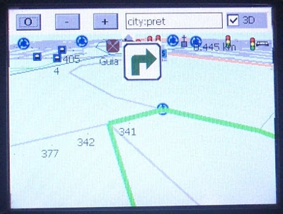
Gosmore is a routing and viewer of OSM XML data such as the whole planet.osm or other osm files from Geofabrik (see downloads) or Cloudmade (see downloads).
It includes many features, like acquiring the current location from a GPS receiver, turn-by-turn navigation, and recording of tracklogs in GPX format.
Releases.
The stable 2010.1 version is available for download (see below). 2010.2 is under development. In future it will be easier to customize the user interface and a few other improvements.
Features.
A 2D map viewing window (Mercator projection), as well as a 3D bird's eye view.
Incremental search of all tags. Results are ordered from nearest to farthest.
Routing with basic Relation:restriction support.
Obtain the current location from a GPS receiver (via gpsd using Linux).
The ability to add POI's and trace ways which get saved to a .osm format file ready for import into JOSM
The ability to automatically switch maps on-the-fly, so you can access the whole planet.
Alternatively install the debian package that may be slightly out of date.
On FreeBSD and MacOSX, you will need to use GNU Make (gmake) to build as the Makefile is in a GNU Make format, rather than the traditional BSD make.
On MacOSX, you will have to install X11, the developer tools and maybe additional packages that are not listed here but are fairly standard when compiling stuff. Feel free to list them if you find any that are not listed here.
After these steps complete, gosmore should appear on your menus. Gosmore will run fairly responsively on a 256 MB machine.
After finding a city or location you are interested in, choose the 'Update Map' function (see the Auto Pak file section below). Downloaded files will be stored in $HOME/.gosmore/
The main window consists of
the buttons: Options, + zoom in / increase, - zoom out / decrease and 3D.
the search box
The main window with 4 modes:
Map Click or drag to pan.
Search Results. Direction, distance, type and names are displayed. Click to select.
Options for selecting icon types, detail level and routing settings. Drag to see all of them. Click to select. See Gosmore/Translations Note that not all options are supported on all platforms.
Add Object Type List. Select the object you want to add.
Add Object Name dialog. Set the name.
the location bar (GTK/Linux only) Copy and paste to / from JOSM or the www.openstreetmap.org permalinks.
The GTK version will look for way points in any selected text in any other application (clipboard mechanism). For example, you can select geocache log and click on the gosmore map window to see where the points are.
When you exit Gosmore it will also save your options and location to gosmore.opt. This file will normally be located in your home directory. Under Windows and Windows Mobile it will be stored in '\My Documents' unless the file was found on in the same directory as gosmore.exe at startup. So most people place an empty gosmore.opt file on their SD card.
At exit it will also create 'YYMMDD-HHMMSS-Vehicle.osm' and 'YYMMDD-HHMMSS.gpx' files that you can open with JOSM:
Download data to the same layer.
Edit. To find the pending changes search for 'modified'.
Upload
Changing the CommPort and BaudRate settings (Windows Mobile only) requires restarting the application.
Activate ValidateMode to see unnamed roads.
Activate FullScreen and restart for more screen space.
Set Layout (Windows / Windows Mobile only) to 1 to hide the top bar. Set it to 2 on displays that are too narrow for the top bar (width less than 300 pixels).
Some options like ViewInOSM and UpdateMap is only supported under Linux / Gnome, while others like ZoomIn/OutKey is only supported under Windows or Windows CE.
LoadGPX is not implemented.
Activate the 'Exit' option to close the application and write the GPX file, the OSM file and the options.
Bugs.


It includes many features, like acquiring the current location from a GPS receiver, turn-by-turn navigation, and recording of tracklogs in GPX format.
Releases.
The stable 2010.1 version is available for download (see below). 2010.2 is under development. In future it will be easier to customize the user interface and a few other improvements.
Features.
A 2D map viewing window (Mercator projection), as well as a 3D bird's eye view.
Incremental search of all tags. Results are ordered from nearest to farthest.
Routing with basic Relation:restriction support.
Obtain the current location from a GPS receiver (via gpsd using Linux).
The ability to add POI's and trace ways which get saved to a .osm format file ready for import into JOSM
The ability to automatically switch maps on-the-fly, so you can access the whole planet.
### Example for Ubuntu or Debian ###
sudo apt-get install libxml2-dev libgtk2.0-dev g++ make subversion libcurl4-gnutls-dev libgps-dev
svn co http://svn.openstreetmap.org/applications/rendering/gosmore/
cd gosmore
./configure
make
sudo make install
### Example for Fedora 13 ###
su -c "yum install libxml2-devel gtk2-devel gcc-c++ make subversion libcurl-devel gpsd-devel"
svn co http://svn.openstreetmap.org/applications/rendering/gosmore/
cd gosmore
./configure
make
sudo make install
These instructions are for Ubuntu Lucid.
Create a temporary folder.
Download and install CeGCC.
- mkdir ~/temp_gosmore
- cd ~/temp_gosmore
Download and extract required 32 bit libraries (required for 64 bit only).
- wget http://prdownloads.sourceforge.net/project/cegcc/cegcc/0.59.1/mingw32ce-0.59.1.tar.bz2
- tar xvjf mingw32ce-0.59.1.tar.bz2
- sudo cp -r ./opt/mingw32ce /opt
Remove the temp directory
- wget http://mirrors.kernel.org/ubuntu/pool/main/m/mpfr/libmpfr1ldbl_2.4.2-3ubuntu1_i386.deb
- wget http://mirrors.kernel.org/ubuntu/pool/main/g/gmp/libgmp3c2_4.3.2+dfsg-1ubuntu1_i386.deb
- dpkg -x libmpfr1ldbl_2.4.2-3ubuntu1_i386.deb . (don't forget the '.' at the end)
- dpkg -x libgmp3c2_4.3.2+dfsg-1ubuntu1_i386.deb . (don't forget the '.' at the end)
- sudo cp usr/lib/* /usr/lib32/
Add libraries to $PATH
- cd ../
- rm -rf temp_gosmore
cd to location of source files then
- export PATH=/opt/mingw32ce/bin/:$PATH
- export LD_LIBRARY_PATH=/usr/lib32:/usr/lib:$LD_LIBRARY_PATH (required for 64 bit only).
- make arm-mingw32ce-gosmore.exe
Alternatively install the debian package that may be slightly out of date.
On FreeBSD and MacOSX, you will need to use GNU Make (gmake) to build as the Makefile is in a GNU Make format, rather than the traditional BSD make.
On MacOSX, you will have to install X11, the developer tools and maybe additional packages that are not listed here but are fairly standard when compiling stuff. Feel free to list them if you find any that are not listed here.
After these steps complete, gosmore should appear on your menus. Gosmore will run fairly responsively on a 256 MB machine.
After finding a city or location you are interested in, choose the 'Update Map' function (see the Auto Pak file section below). Downloaded files will be stored in $HOME/.gosmore/
The main window consists of
the buttons: Options, + zoom in / increase, - zoom out / decrease and 3D.
the search box
The main window with 4 modes:
Map Click or drag to pan.
Search Results. Direction, distance, type and names are displayed. Click to select.
Options for selecting icon types, detail level and routing settings. Drag to see all of them. Click to select. See Gosmore/Translations Note that not all options are supported on all platforms.
Add Object Type List. Select the object you want to add.
Add Object Name dialog. Set the name.
the location bar (GTK/Linux only) Copy and paste to / from JOSM or the www.openstreetmap.org permalinks.
The GTK version will look for way points in any selected text in any other application (clipboard mechanism). For example, you can select geocache log and click on the gosmore map window to see where the points are.
When you exit Gosmore it will also save your options and location to gosmore.opt. This file will normally be located in your home directory. Under Windows and Windows Mobile it will be stored in '\My Documents' unless the file was found on in the same directory as gosmore.exe at startup. So most people place an empty gosmore.opt file on their SD card.
At exit it will also create 'YYMMDD-HHMMSS-Vehicle.osm' and 'YYMMDD-HHMMSS.gpx' files that you can open with JOSM:
Download data to the same layer.
Edit. To find the pending changes search for 'modified'.
Upload
Changing the CommPort and BaudRate settings (Windows Mobile only) requires restarting the application.
Activate ValidateMode to see unnamed roads.
Activate FullScreen and restart for more screen space.
Set Layout (Windows / Windows Mobile only) to 1 to hide the top bar. Set it to 2 on displays that are too narrow for the top bar (width less than 300 pixels).
Some options like ViewInOSM and UpdateMap is only supported under Linux / Gnome, while others like ZoomIn/OutKey is only supported under Windows or Windows CE.
LoadGPX is not implemented.
Activate the 'Exit' option to close the application and write the GPX file, the OSM file and the options.
Bugs.
In order of importance:
Routing is not calibrated. There are a number of special features, like avoidance of major intersections and turning over oncoming traffic, but the constants can be improved.
Turn restrictions with complex vias are ignored.
Verbal instructions do not work well on motorways.
A number of important platforms aren't supported (OpenTom, Symbian, Android, iphone etc). Note however that the WinCE Core that gosmore requires is cheap [6]. Many of the house brand GPSs are WinCE based.
32 bit machines can create and use only pak files smaller than 2GB. Rebuild gives segmentation fault on computers with less than 1GB of virtual memory.
Pak file cannot be dynamically updated e.g. osmosis. However, since the objects we map (roads etc) change infrequently and mappers take very long to resurvey existing data, you will most likely only find the spots where the pak file is out of date if actively go looking for them.
Pak file cannot be moved to a machine with a different endianness.
If double decker bridges are drawn with 2 or more nodes on exactly the same latitude and longitude, gosmore may make incorrect routing decisions. (It can be solved at the cost of a 10% larger pak file).
No way of completely disconnecting from GPS com port. Causes battery drain when internal GPS is activated by just connecting to the proper com port (on WM5 at least).
When in current direction = up (north upwards=0) mode, stopping at a crossing causes slight precision improvements due to gps averaging which can shift position slightly in any (random) direction, which causes the map to rotate wildly, disorientating the driver (and probably giving wrong instructions if the route is recalculated). Probably a longer (eg 10 m distance, not time) average period should be used to determine direction before rotating the map.
Screenshots.

Custom Search
If you liked this article, subscribe to the feed by clicking the image below to keep informed about new contents of the blog:


0 commenti:
Post a Comment